Valldalsleden
Valldal - Lesja - Dovrefjell
Difficulty: Medium, Demanding
Type of terrain: Forest trails, gravel roads, mountains. Steady ascent from start to finish.
Valldalsleden runs from Sylte in Norddal municipality, up Valldalen to Grønningseter, through Reinheimen National Park, further down through Lesja and into Dombås. From here the trail goes up to Fokstugu on Dovrefjell where it connects to Gudbrandsdalsleden. Valldalsleden offers varied terrain, with multiple kinds of accommodation and is considered medium to demanding. This is both due to the slope and terrain, but also because it may be necessary to carry some food and equipment.
This path was St. Olav's escape route in the winter of 1028 - 1029. He landed his ship in Valldal and went over the mountain to Lesja and Dovre. The journey is described in Snorri's "Saga of St. Olaf" which you can find in Heimskringla.
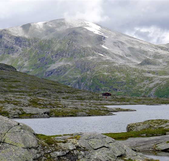
It is a scenic trail with everything from fjord landscapes to steep gorges and mountain terrain. It can be walked in about a week, but it is also well suited for those who want to take their time, who want to reflect on the many impressions that come forth on the hike. Be aware that there may be sudden weather changes and that there may be snow in the mountains until well into the season. We recommend talking to the Pilgrim Center Dovrefjell before setting out on a hike. We also recommend bringing a map and a compass as there may be poor cell phone coverage in some areas along the trail.
****
There are enough shelters/cabins along the way. It not necessary with a tent, but of cause, it depends on how long stages you want to walk per day. The average is 20 km.
Valldalsleden from Valldal to Dovre is parted in 9 recommended stages:
1. Valldal-Alstad 16,5 km
2. Alstad-Tjønnebu 12,8 km
3. Tjønnebu-Vakkerstøylen 15,9 km
4. Vakkerstøylen-Rånå 22,1
5. Rånå-Lesjaskog 16,5 km
6. Lesjaskog-Lesjaverk 16,2 km
7. Lesjaverk-Lesja 29,3 km
8. Lesja-Dombås 16,8 km
9. Dombås-Fokstugu 10 km
There are two grocery stores in the centre of Valldal, before you start hiking. If you book accommodation at Juvet landskapshotell or Gudbrandsjuvet camping (between stage 1-2), there is also possibilities for eating there before you continue. You can also buy tin-can food at the DNT cabins Tjønnebu https://ut.no/hytte/10543/tjnnebu and Vakkerstøylen https://ut.no/hytte/10549/vakkerstylen . The next possibility to buy food is in Bjorli, the grocery store is 3km from the pilegrim route (between stage 4 and 5). If you chose not to stop in Bjorli, the next grocery store is in Lesjaskog between stage 5 and 6.
For detailed planning you can use the map and the information here: https://pilegrimsleden.no/en/trails/valldalsledenYou can zoome in and out, and also find the contact information and information about the accomodations along the path.
From mid/late July, you don’t need to prepare for snow.This year there was little snow in the mountains compared to the usual normal summer. (DNT Sunnmøre can be contacted for questions). Bring walking/hiking poles.
In general:
If you are new with pilgrimage, may be a part of Gudbrandsdalsleden is better for you? Dovrefjell and further to Trondheim is beautiful as well, and you will meet other pilgrims. Valldalsleden is not recommended if this is your first pilgrimage.
Useful reading